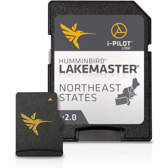
LakeMaster Plus digitālās kartes ir iekļautas Micro SD kartē (ar iekļautu SD kartes adapteri), kas ir saderīga ar visiem GPS aprīkotiem HELIX, SOLIX, ONIX un ION sērijas modeļiem un atsevišķiem 600-1100 sērijas modeļiem. Viegli saskatāms ēnojums izceļ sekla ūdens apgabalus regulējamā diapazonā līdz 30 pēdām, un dziļuma kontūras un krasta līnijas var sinhronizēt ar faktiskajiem ezeru, rezervuāru un upju ūdens līmeņiem. LakeMaster Plus ļauj skatīt augstas izšķirtspējas ūdeņos gaisa attēlu pārklājumu, lai redzētu līča kanālu ieeju un izeju, lai redzētu, cik tālu stiepjas rifu vai nezāļu līnija, un lai izceltu sekla ūdens akmeņu krāvumus, stāvus kritumus. un citas funkcijas. Šajā LakeMaster Plus Northeast States izdevuma 2. versijā ir vairāk nekā 130 augstas izšķirtspējas ezeru un vairāk nekā 1700 ezeru no PA, NJ, NY, CT, MA, VT, NH un ME, pievienojot vairāk nekā 200 jaunus ezerus kopš iepriekšējās versijas ( 27 augstā izšķirtspējā). Iegūstiet papildu priekšrocības makšķerēšanai ar LakeMaster Plus kartēšanu, kas papildina augstas kvalitātes aerofotografēšanu ar nepārspējamu precizitāti un detaļām, viegli nolasāmām kontūrām, izceltiem dziļuma diapazoniem un ritināmiem ezeru sarakstiem.
EAN: 0082324050046
Kategorijas Elektronika, Auto un transportlīdzekļi Elektronika, Kuģu elektronika, Marine GPS Chartplotters,
| Brand | Humminbird |
| Brand Name | Humminbird |
| Color | Black |
| Color | Black |
| Compatible Devices | all GPS-equipped HELIX, SOLIX, ONIX, and ION, 600-1100 Series models |
| Customer Reviews | 4.3 4.3 out of 5 stars 85 ratings 4.3 out of 5 stars |
| Fishing Technique | Any |
| Included Components | Includes micro SD card with full size adapter and water resistant SD card carrying case. |
| Included Components | Includes micro SD card with full size adapter and water resistant SD card carrying case. |
| Item Dimensions LxWxH | 8 x 6 x 2 inches |
| Item Dimensions LxWxH | 8 x 6 x 2 inches |
| Item Package Dimensions L x W x H | 7.4 x 5.39 x 0.63 inches |
| Item Weight | 0.29 Pounds |
| Item Weight | 0.29 Pounds |
| Manufacturer | Humminbird |
| Map Type | North America |
| Material | Plastic |
| Model Name | LakeMaster PLUS |
| Model Name | LakeMaster PLUS |
| Number of Items | 1 |
| Package Weight | 0.16 Kilograms |
| Part Number | 600045-4 |
| Screen Size | 27 Inches |
| Size | LakeMaster Plus |
| Sport Type | Fishing |
| Sport Type | Fishing |
| Style | LakeMaster Plus |
| Suggested Users | Unisex-Adult |
| Warranty Description | 30-day manufacturer |